
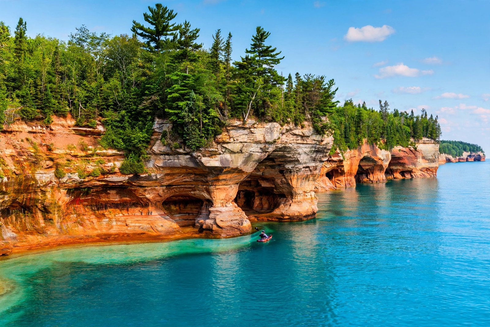
There is a stretch of Michigan shoreline where the cliffs look hand-painted. Bands of red, orange, blue, green, brown and black run down towering sandstone walls that rise straight out of Lake Superior, the largest and coldest of the Great Lakes. Arches, sea caves and stone turrets jut into water so clear and blue it hardly seems real. This is Pictured Rocks National Lakeshore, a wild and beautiful corner of Michigan’s Upper Peninsula that still feels like a secret, even though it welcomes close to a million visitors a year, according to the National Park Service.
Most first-time visitors arrive expecting a pretty viewpoint or two. What they find instead is 42 miles of Lake Superior shoreline packed with waterfalls, beaches, sand dunes, a historic lighthouse and some of the most photographed rock formations in the Midwest. Here is everything you need to know to plan a visit to Michigan’s hidden gem on Lake Superior.
What Makes Pictured Rocks So Special?
The name says it all. The cliffs get their colors from mineral stains, created when groundwater seeps out of cracks in the sandstone and trickles down the rock face. As the National Park Service explains, iron paints the rock red and orange, copper adds blue and green, and manganese leaves brown and black streaks. The result looks like someone tipped buckets of paint down the cliffs, and the colors shift with the light all day long. The Park Service notes that late afternoon or early evening sunlight brings out the richest colors, which is why the sunset boat cruises are so popular.
The cliffs are sandstone laid down in shallow seas hundreds of millions of years ago, rising 50 to 200 feet and stretching for more than 15 miles along the shoreline. Waves, wind and ice have carved the soft rock into sea caves, arches, blowholes and stone spires, including Chapel Rock, Miners Castle, Lover’s Leap and Grand Portal Point, the highest point on the cliffs at more than 200 feet tall.
What makes the place feel different from other scenic parks is how alive it still is. Erosion never stops here, and the shoreline changes a little every year as wind, waves and winter ice wear the cliffs away. In 2006, one of the two rock pillars crowning Miners Castle collapsed into the lake overnight. Visitors are asked to stay on marked trails and viewing platforms and never carve into the rock, so this fragile landscape lasts for the next generation.
America’s First National Lakeshore
Pictured Rocks holds a special place in American conservation history. It was authorized on October 15, 1966, as America’s first National Lakeshore, and it was formally established as a unit of the National Park System in 1972. The idea had been building for years: in the late 1950s, the Park Service surveyed thousands of miles of Great Lakes shoreline looking for places worth protecting, and this stretch stood out. Senator Philip Hart of Michigan introduced the bill, and President Lyndon B. Johnson signed it into law.
The lakeshore stretches from Munising in the west to Grand Marais in the east, covering more than 73,000 acres of cliffs, forest, dunes and inland lakes, all managed by the National Park Service. The western end, around Munising, holds the famous cliffs and the busiest viewpoints. The eastern end is quieter, with the Grand Sable Dunes, the Au Sable Light Station and long, lonely beaches. Between them lies the Beaver Basin Wilderness, a backcountry of lakes and forest where you can hike for hours and meet almost no one.
All park visitors aged 16 and older are required to hold a park pass, which you can buy online or at a visitor center. Check the National Park Service website for current pass details before you go, and stop at the Munising Falls Visitor Center when you arrive for maps, trail conditions and ranger advice.
The Sights You Can’t Miss
Miners Castle is the most visited spot in the park, and for good reason. The multi-turreted sandstone outcrop juts above Lake Superior a short drive east of Munising, and three viewing platforms offer different angles on it. The two upper platforms are wheelchair-accessible and only a short walk from the parking lot, while the lower platform involves stairs and steep inclines. The walk to the overlooks ranges from 200 to 1,300 feet one way, so this is the easiest of the park’s big sights to reach.
Chapel Rock is the park’s most photographed formation, and it earns the attention. A freestanding sandstone pillar rises from the water with a single white pine growing from its top, kept alive only because its roots reach back across a natural root bridge to the mainland cliff. Visitors are asked to keep off the protected rock and enjoy the view from the trail above. Chapel Rock sits along the Chapel Loop trail, past Chapel Falls, a 60-foot waterfall. Reaching Chapel Rock and Chapel Beach is a 6.2-mile round trip, a half-day commitment rather than a quick stop.
Grand Portal Point is the highest point on the cliffs, standing more than 200 feet above the lake, and its great arch is one of the defining images of Pictured Rocks, best seen from the water. Lover’s Leap, a sandstone arch rising out of the lake, is another favorite of photographers.
At the eastern end of the park, the Au Sable Light Station stands on a lonely stretch of shore about 30 miles northeast of Munising. The lighthouse has guided ships along Lake Superior’s treacherous southern shore since the 1870s, and its buildings are listed on the National Register of Historic Places. You can reach it on a 3-mile round-trip walk from the Hurricane River Campground along an old access road that is part of the North Country National Scenic Trail. In summer, guided tours of the lighthouse are offered. Shipwreck remains dot the shoreline along the way, a quiet reminder of how dangerous this lake once was for sailors.
Seeing the Cliffs from the Water
The Park Service says it plainly: the best way to see the geologic layers and colors of the Pictured Rocks cliffs is from the water. From a boat, you look up at the full height of the cliffs, drift into the mouths of sea caves, and watch the colors deepen as the sun drops. Pictured Rocks Cruises is the only concessionaire authorized by the National Park Service to offer non-stop narrated boat tours of the cliffs.
Cruises run from mid-May to mid-October, departing from the city dock in downtown Munising. The Classic Cruise and the Sunset Classic Cruise last about 2 hours and 35 minutes, while the Spray Falls Cruise and the Sunset Spray Falls Cruise run about 2 hours and 5 minutes. All cover roughly 40 miles round trip. The Spray Falls cruises continue further along the lakeshore, weather permitting, to view an additional waterfall, Spray Falls, and the sunset versions depart later so passengers can watch the setting sun light up the cliffs.
Book in advance, because cruises frequently sell out, especially in July and August and on holiday weekends. Arrive at least 20 minutes before departure, and 30 to 45 minutes early in peak season for first choice of seats. Dress in layers, since temperatures on Lake Superior can run 10 to 15 degrees cooler than on shore. Pets are not allowed on the boats, but the company offers kennels on site, and cruises may be canceled if the lake is rough, so check the current status before you head to the dock.
The Best Hikes in Pictured Rocks
The lakeshore offers about 100 miles of hiking trails, from short paved walks to a 42-mile stretch of the North Country National Scenic Trail that runs the length of the park. Here are the hikes that give you the most for your effort.
The Chapel Loop is the park’s signature hike. The full loop, including Mosquito Falls, is 10.5 miles, and it passes Chapel Falls, Chapel Rock, Chapel Beach and the cliff tops before returning past Mosquito Falls. It is a full-day hike over sometimes muddy and rough trail, with no pets allowed anywhere in the Chapel and Mosquito area. If 10.5 miles is too much, hike out and back to Chapel Rock and Chapel Beach (6.2 miles round trip) or just to Chapel Falls (2.5 miles round trip).
Miners Falls Trail is an easy 1.2-mile round trip through the forest to the park’s most powerful waterfall, where the Miners River drops 50 feet over a sandstone cliff. A set of 64 steps leads down to a lower viewing platform. Nearby, the Miners Castle to Miners Beach trail runs 2 miles round trip downhill to a scenic beach, with the option of a pickup at the beach parking lot.
Munising Falls is the easiest waterfall in the park to reach. An 800-foot paved walk leads up a cool, shaded sandstone canyon along Munising Creek to the main viewing platform, where the 50-foot falls drop over a cliff. Two sets of stairs lead to elevated platforms, and the trail is a lovely walk in winter, when the falls freeze into curtains of ice.
For the eastern end of the park, the Sable Falls Trail is a 0.4-mile round trip that starts with 168 steps down to the base of the falls and continues along Sable Creek to a beach on Lake Superior. The Grand Sable Dunes Trail, a 0.6-mile round trip, climbs through jack pine forest into open dunes. The Log Slide Overlook Trail is a short 0.25-mile round trip to a viewpoint over the dunes and the lake, with the Au Sable Lighthouse visible in the distance.
Wherever you hike, check trail conditions at a visitor center first, carry enough food and water, and stay back from cliff edges, which can be unstable. Bicycles and drones are not allowed on park trails or within park boundaries, and backcountry camping requires a permit.
When to Visit Pictured Rocks
Summer is the classic season, and also the busiest. The boat cruises run from mid-May to mid-October, the waterfalls are full, the beaches are at their best, and every trail and viewpoint is open. July and August bring the biggest crowds, so book cruises and lodging early and arrive at popular trailheads in the morning. Late spring and early fall are quieter and can be wonderful. In autumn, the maple forests above the cliffs turn red and gold, and the low, golden light makes the mineral colors on the rock glow. Sunset cruises are at their best in late summer and early fall.
Lake Superior sets the weather here, and it can change fast. Mornings can be foggy and afternoons cool and windy, so layers are the rule in every season. Black flies, mosquitoes and biting stable flies can be a nuisance between late May and September, so pack long pants and thick socks along with insect repellent. Winter turns the park quiet and starkly beautiful, with frozen waterfalls and ice formations along the shore, but services are limited and the boat cruises do not run.
Planning Your Trip
Munising is the gateway town for Pictured Rocks, and it is the place to base yourself. The town sits just outside the park’s western end, about 43 miles east of Marquette, and it holds the visitor center, the cruise dock, restaurants, shops and most of the area’s lodging. Grand Marais, at the park’s eastern end, is a smaller and quieter base for the dunes and the lighthouse. The park has three rustic drive-in campgrounds and 13 backcountry camping areas.
Give yourself at least two days: one for a boat cruise and the Miners Castle and waterfall viewpoints, and a second for a long hike like the Chapel Loop or the Au Sable Light Station. With a third day, add a kayak trip with a permitted outfitter or a slow drive with stops at the beaches and overlooks.
Pictured Rocks is the kind of place that sneaks up on you. People come for a photograph of a painted cliff and leave talking about the silence of a Lake Superior beach at dawn, the roar of a waterfall in a forest canyon, or the way the rock glowed orange as the sun went down. It was America’s first National Lakeshore for a reason, and sixty years after Congress protected it, it still feels like a discovery.
Frequently Asked Questions
Where is Pictured Rocks National Lakeshore?
Pictured Rocks National Lakeshore sits on the southern shore of Lake Superior in Michigan’s Upper Peninsula, between the towns of Munising in the west and Grand Marais in the east. It protects about 42 miles of Lake Superior shoreline.
What are the Pictured Rocks made of?
The cliffs are sandstone, laid down in ancient shallow seas. Their famous colors come from mineral stains: iron creates red and orange, copper creates blue and green, and manganese creates brown and black streaks.
How long is the Pictured Rocks boat cruise?
Cruises run 2 to 2.5 hours and cover about 40 miles round trip. The Classic Cruise lasts about 2 hours and 35 minutes, and the Spray Falls Cruise lasts about 2 hours and 5 minutes. Cruises operate from mid-May to mid-October, departing from the city dock in downtown Munising.
Can you hike to Chapel Rock?
Yes. Chapel Rock is reached on foot from the Chapel parking lot. The round trip to Chapel Rock and Chapel Beach is 6.2 miles, and the full Chapel Loop, including Mosquito Falls, is 10.5 miles. No pets are allowed on the trails in the Chapel and Mosquito area.
When is the best time to visit Pictured Rocks?
Summer offers the fullest experience, with boat cruises, warm weather and all trails open. Early fall brings autumn color and fewer crowds, and the low evening light makes the cliff colors glow. Cruises run from mid-May to mid-October, so plan a boat trip inside that window.
Do you need a pass to visit Pictured Rocks?
Yes. All park visitors aged 16 and older are required to hold a park pass. You can buy a pass online or at a visitor center, and you should check the National Park Service website for current pass details before your trip.
Related reading
- Apostle Islands: Wisconsin’s Sea Caves on Lake Superior
- Great Lakes Facts: America’s Freshwater Giants
- Dry Tortugas: Florida’s Remote Island Hidden Gem
Sources: National Park Service, Pictured Rocks National Lakeshore (nps.gov/piro); National Park Service, Geologic Formations of Pictured Rocks (nps.gov); National Park Service, Day Hikes (nps.gov); National Park Service, Pictured Rocks Cruises Boat Tour (nps.gov); Pictured Rocks Cruises, FAQs and policies (picturedrocks.com).